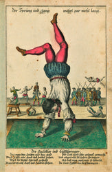
Free Shipping on all USA orders!

Massachusetts, Connecticut, Rhode Island- Antique Map (1866)

Don't miss out again

Sign up and be the first to know when new pieces arrive!

Wow, what a remarkable piece of history from 1866. Printed in black and white by Mitchell Maps, and later colored meticulously by hand, the appearance and antiquity of each map is truly one-of-a-kind.

Named after creator Augustus Mitchell, these authentic vintage maps were integral during the Treaty of Paris to solve border disputes. Mitchell Maps are proven to be the most comprehensive maps of both the Eastern and Western Hemisphere. Consider yourself lucky if you manage to get your hands on this unique pieces of history. Note, check out the ornate bordering on each map; the trademark stamp of a Mitchell Map! 

Condition: Age appropriate wear. Paper toning in accordance with the print's age. Marks/stains as per photo. Wear around the edges and minor paper loss might be present in some prints. Please refer to each print's photo to get a better understanding of the condition.

Year: c.1866 - 158 years old

Size: 15.5" x 12.5" (39cm x 32cm)


GLOBAL SHIPPING

Customer Reviews

Based on 1 review
100%
(1)
0%
(0)
0%
(0)
0%
(0)
0%
(0)
t
try (Medfield, MA, US)
Awesome Map!

Thank you for being a source to make this map available. Very special for my wife and I.

Thank you for your review Todd! It makes us happy to know that it has special significance for you and your wife and we're glad to have been a part of making it possible for you to own such a unique item.

Search