FREE Standard Shipping on USA orders over $125
FREE Standard Shipping on USA orders over $125


Sign up and be the first to know when new pieces arrive!
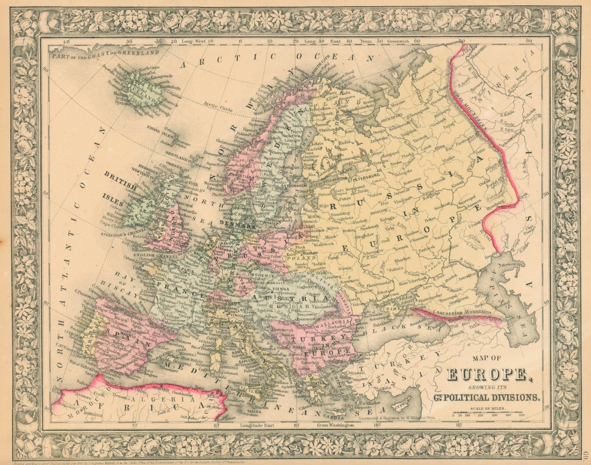
Wow, this original map of Europe showing Political Divisions is a remarkable piece of history from 1860. Printed in black and white, and later colored meticulously by hand, the appearance and antiquity of each map is truly one-of-a-kind.
Named after creator Augustus Mitchell, Mitchell Maps were proven to be the most comprehensive maps of both the Eastern and Western Hemisphere. Consider yourself lucky if you manage to get your hands on this unique piece of history. Note, check out the ornate bordering on each map; the trademark stamp of a Mitchell Map!
Condition: Age appropriate wear. Paper toning in accordance with the print's age. Marks/stains as per photo. Wear around the edges and minor paper loss might be present in some prints. Please refer to each print's photo to get a better understanding of the condition.
All items are carefully hand-packed and shipped in a sturdy tube within 3 business days of payment unless otherwise indicated. Some items which were previously folded or not suitable for rolling will be sent in a flat pack. Please note that an adult signature may be required upon delivery, so we are unable to ship to PO boxes.
Express Shipping:
An optional Express Shipping (estimated 2–3 business days) upgrade is available at checkout for domestic U.S. orders.
Unless otherwise noted in the product description or a special offer, shipping rates are as follows:
Posters
Antique Prints, Cover Art & Illustrations
NOTE for International Shipments: Shipping rates do not include international taxes or duties which may be charged by your country's border customs control agency.
Our Guarantee
All of our posters are guaranteed to be authentic and as described in the product description to the best of our knowledge and belief, and in good faith. Quite simply, if you are not satisfied with your purchase for any reason, simply contact us within 14 days of receipt and we'll gladly accept your return, providing the item is in the same condition as it was sent.
Returns
Our policy lasts 14 days. If 14 days have gone by since your purchase, unfortunately, we can’t offer you a refund or exchange.
To be eligible for a return, your item must be in the same condition that you received it. It must also be sent in the original packaging.
There are certain situations where only partial refunds are granted (if applicable). Any item not in its original condition, is damaged or missing parts for reasons not due to our error. Any item that is returned more than 14 days after delivery may also be ineligible.
Once your return is received and inspected, we will send you an email to notify you that we have received your returned item. Your refund will be processed, and a credit will automatically be applied to your credit card or original method of payment, within two business days. Original shipping costs are not refundable.
Shipping
To return your product, you should mail your product to:
Authentic Vintage Posters- RETURNS
7514 Girard Ave
STE 1615
La Jolla, CA 92037
You will be responsible for paying for your own shipping costs for returning your item. Shipping costs are non-refundable.
If you are returning an item over $75, you should consider using a trackable shipping service and purchasing shipping insurance. We can't guarantee that we will receive your returned item.
We Buy Posters


